

Apr 16, 2025
Digital twins allow smart cities to anticipate and manage infrastructure, energy, and mobility, optimizing resources and enhancing safety.
As cities grow, operational challenges become increasingly complex: from traffic management to water or energy consumption in public spaces, as well as the maintenance of critical infrastructure. The need to monitor these areas constantly and efficiently is becoming more urgent, as a lack of control and security can lead to risks for citizens and increased operational costs for administrations.
In fact, problems such as traffic jams, environmental impact, or urban incidents have a direct impact on the economy of cities. According to the AEOC report ‘Towards a Sustainable Model of Urban Goods Distribution in Spain’, it states that these inefficiencies generate annual losses between 15.1 and 23.8 million euros, representing an economic cost of 2% of the national GDP.
Unfortunately, it is not uncommon to find damaged infrastructure, poorly maintained pavements, or public systems that fail to respond effectively in critical moments. What is important is to prevent these situations from leading to serious incidents that compromise public safety.
In this scenario, it is essential to move towards more responsible and proactive management. For this, we need tools that offer visibility, control, and capacity for reaction. The digital twin technology emerges as a key ally for monitoring the strategic areas of the city, reducing response times, optimizing resources, and preventing incidents before they occur.
Main Challenges Hindering the Operational Efficiency of Smart Cities
Infrastructure Monitoring: The Challenge of Digitalization in the Smart City
The monitoring of critical infrastructure such as pumping stations, electrical panels, urban HVAC systems, or water tanks remains a weak point in many Spanish cities. Although digitalization and urban innovation are frequently discussed, the reality is that a large part of this infrastructure is still managed manually or with disconnected systems, which greatly limits operational efficiency.
This reactive approach is problematic because incidents are often detected late (when the damage is already done), maintenance crews must make rounds without certainty of a failure, and there is no unified view of the state of the infrastructure. Each system acts separately, without interoperability or traceability, and without real-time data that enables informed decision-making.
And most concerning: without historical data or predictive analysis, reliance is placed on intuition rather than evidence. Does this sound familiar? If you work in urban management, you probably find this all too familiar.
Inefficient Management of Water and Energy Consumption in Urban Environments
Excessive water and energy consumption is one of the most challenging problems to tackle in a city that wants to be smart… and sustainable. The causes are many, but they all converge on the same issue: lack of visibility, lack of control, and lack of integration.
Undetected leaks in public water networks could lead to losses of up to 30% of the total volume in extreme cases, such as in cities with aging infrastructure. According to data from the National Statistics Institute (INE), in 2022, it was estimated that 16.3% of the total water supplied to urban supply networks in Spain was lost due to leaks, breaks, and uncontrolled failures.
Public lighting often operates on fixed schedules without considering the actual level of occupancy or brightness, resulting in unnecessary energy expenditure every night. Additionally, it is estimated that at a national level, municipal outdoor lighting presents an estimated electricity consumption of 5,296 GWh per year and a cost of 741 million euros.
The problem is not only environmental: it is economic, operational, and of public reputation. Citizens expect efficiency, and administrations often lack tools to demonstrate or improve it.
Inefficient Traffic and Urban Parking Management
Urban mobility continues to be an unresolved challenge in most Spanish cities. Daily, traffic jams and a lack of parking spaces generate frustration, pollution, loss of productivity, and inefficient use of public space.
The concern is not only the problem itself, but how it is managed: without real-time data, without heat maps, without a historical record of occupancy by time slots or zones. Decision-making is often based on intuitions or citizen complaints, not on evidence.
A study by the Foundation for Applied Economic Studies (FEDEA) estimates that traffic jams generate time losses that translate into an economic cost of 187.5 million euros annually in Madrid and 175.5 million in Barcelona.
The same FEDEA report highlights that polluting emissions cause the deaths of 3.3 million people worldwide each year, with traffic being one of the main causes. In Spain, there are an average of 31,520 deaths attributed to air pollution annually, according to the European Environment Agency.
Deterioration of Roads and Road Infrastructure
The state of road infrastructure in Spain has become a growing concern. According to the Spanish Road Association (AEC), "one in every thirteen kilometers of the Spanish road network presents significant deterioration in more than 50% of the pavement surface, accumulating potholes, wheel ruts, and longitudinal and transverse cracks" that compromise both comfort and safety of circulation.
The maintenance of roads and urban thoroughfares continues to operate, in many cases, under a reactive model. Action is only taken when damage has already occurred: a pothole that becomes a sinkhole, a lifted sidewalk after a citizen complaint, or a road closed after an unexpected breakage.
This model creates a triple problem: risk for road safety, higher repair costs, and lack of budgetary planning. Furthermore, lacking a preventive strategy impedes prioritizing actions based on the real state of assets.
Today, most municipalities do not have a consolidated data layer on the state of their road infrastructure. It is unknown how long a particular path has gone without intervention, which areas have the most accumulated incidents, or how deterioration could be anticipated through variables such as traffic, rainfall, or type of pavement.
From Uncertainty to Efficiency: The Benefits of Implementing Digital Twins in Urban Management
Can you imagine a city capable of seeing everything that happens on its streets in real time? Knowing exactly when a pipe is losing water or the deterioration of a road before it becomes a risk for citizens.
It is not fiction; it is technology at your fingertips. And it is called a digital twin.
Digital twins have become one of the most powerful solutions to improve the operation of Smart Cities. Their ability to combine virtual representations in 3D, data analysis, and predictions with artificial intelligence on a single platform has made them a safe bet for advancing towards more efficient urban management.
According to a report by ABI Research, the use of digital twins in urban planning could generate savings of up to 280 billion dollars worldwide by 2030, thanks to more efficient, sustainable, and prevention-oriented urban planning.
Urban Planning and Maintenance with TOKII: The Revolutionary Digital Twin Platform
At IMMERSIA, we have developed TOKII, a digital twin platform with artificial intelligence that allows data to be centralized and visualized in real time, analyze data from different sources visually, and interact with them intuitively in an immersive 3D environment. This solution is designed to address the operational challenges of smart cities, facilitating more efficient and proactive urban management. It allows incorporating data from sensors, drones, surveillance cameras, traffic lights, and even from roads.
Infrastructure Monitoring with Digital Twins
It allows creating digital replicas of urban assets such as pumping stations, electrical panels, HVAC systems, or transformation centers. These representations facilitate remote and continuous monitoring, incorporating automatic alerts, incident logs, and predictive maintenance. Thus, it is possible to anticipate when interventions will be necessary and avoid reactive maintenance that generates delays and additional costs.
An example of predictive maintenance is the case of Comdiflex, which implemented TOKII to monitor industrial components. Using drones equipped with advanced sensors that collect data detecting variations in the components, such as color codes that change due to corrosion. TOKII processes this information and sends alerts to the responsible personnel when the need for replacement is identified. It is also possible to establish automations to manage orders of the components from the corresponding distributors, optimizing the supply chain and reducing downtime.
Digital Twins for Reducing Energy and Water Consumption:
Thanks to the integration of smart meters and network sensors, TOKII allows visualizing water or energy consumption in buildings, neighborhoods, or municipal facilities. Additionally, the platform detects anomalies such as excessive consumption spikes, leaks, or inefficiencies and represents them intuitively in graphs on 3D models. This allows responsible parties to act before waste increases or problems worsen.
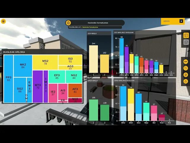
In the case of Tolosaldea LHII, TOKII is directly connected to the solar panels of the building to control consumption centrally. Additionally, a comprehensive building monitoring system (BMS) has been implemented that includes data on electricity consumption, water, ambient temperature, use of electric bicycles at the center, and even data from its Odoo ERP.
Data Analysis for Monitoring Road Infrastructure: Predicting and Preventing Deterioration
TOKII integrates with various data sources, such as IoT sensors, smart cameras, and traffic management platforms, to provide a complete, real-time view of urban mobility. By centralizing this information, the platform allows generating heat maps, visualizing mobility patterns, and predicting congestion. This helps mobility managers quickly identify areas that require intervention, such as the need for more parking spaces, redesigning routes, or prioritizing public transport, based on data.
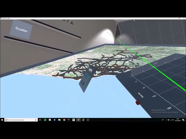
In the project carried out with RACC, we have implemented TOKII to analyze and improve the safety of the Catalan road network. Through data from IoT sensors installed in the road infrastructure, historical accident analysis, and other sources, TOKII allows creating 3D digital representations of sections and categorizing them using color codes. This virtual reality project facilitates the identification of accident patterns and bottlenecks, allowing for understanding the underlying causes of accidents and making data-driven decisions to improve road safety and reduce accident rates.
Anticipating the Deterioration of Roads and Road Infrastructure with TOKII:
TOKII facilitates the tracking of the condition of infrastructure such as pavements, sidewalks, bridges, or tunnels. By integrating data such as traffic, rainfall, and material type, it enables predictions about potential risk areas, such as sections particularly sensitive to sinkhole formation in urban environments, especially in coastal cities.
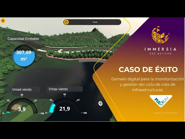
This approach to analysis and visualization is also applied in the case of Fulcrum, where TOKII is used as an integrated platform for managing hydraulic infrastructures such as dams and reservoirs. Through the digital twin, they can visualize data from structural monitoring sensors, topographic and bathymetric surveys, historical meteorological and hydrological data to understand structural movements and anticipate how they will affect the future. Additionally, they also share and visualize technical documents, regulations, images, and other files directly from the platform, allowing for always-up-to-date vision.
Successful Applications of Digital Twin Technology in the Smart City
According to Hexagon, the city of Chattanooga (USA) uses a digital twin fed by data from 500 sources, including traffic cameras and weather stations, to manage traffic, with which they have managed to speed up traffic by up to 30%, increasing energy efficiency and reducing passenger delays.
Virtual Singapore: a project that has turned the entire city into an interactive 3D digital twin. This urban model incorporates real-time data on infrastructure, mobility, climate, and public space usage, and allows simulating scenarios before making decisions: how a new construction will affect traffic, which areas are most vulnerable in case of flooding, or how to reorganize public services to optimize resources.
And the Nanyang technological university in Singapore achieved energy savings of 31% and reduced carbon emissions by 9.6 kilotons.


